What is the wireless video data transmission for mother and daughter UAVs?
Mother UAV is the main drone in the air, responsible for communicating with the ground and other daughter UAV drones in the air.
The daughter UAV is an auxiliary drone in the air, mainly responsible for executing the mission instructions issued by the ground control station through the main drone.
Wildfire surveying drone system description:
Lately, one of our customers asked for a feasible solution to set up a Drone network for wildfire surveying beyond the line of sight, by providing real-time data and video and operating over long distances. For the reason to cover large areas, since we are such a big country, we have proposed this architecture:
A mother UAV capable of flying up to 6 km in altitude and covering a distance of 50 กม., controlled directly via line-of-sight (เดอะ) from the ground control station (กศน). The mother UAV is equipped with a high-resolution inspection camera that transmits a high-quality video stream downlink to the GCS, and it exchanges command and telemetry data with the GCS through full-duplex, two-way communication.
นอกจากนี้, six daughter quadcopter drones connect exclusively to the mother UAV via two-way telemetry data and send their video streams to the mother UAV, which acts as a relay to transmit all data to the GCS. The daughter drones can operate simultaneously, and both the mother UAV and the daughter drones can be commanded from the GCS. The maximum distance between the mother UAV and the daughter quadcopters is set to 15 km LOS which makes it possible to cover a large area and establish beyond the line-of-sight system.
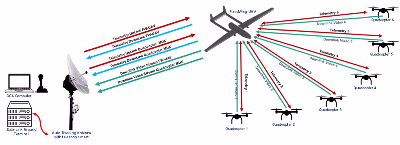
Fig. Overview of the working scenario with all the communication links.
Here’s how it can be applied effectively:
1. Mother UAV as Command-and-Control Center
- High-altitude, long-range surveillance: The mother UAV, with its ability to fly up to 6 km in altitude and cover 50 กม., can act as a high-altitude observation platform for the overall fire area. It can capture high-resolution images and video, which can be streamed in real-time to the ground control station (กศน).
- Coordination hub for daughter drones: The mother UAV can serve as a relay point to manage the daughter drones, coordinating their flight paths to cover specific sections of the fire.
2. Daughter Drones for Detailed Data Gathering
- Simultaneous multi-point surveillance: The daughter drones can be deployed at lower altitudes to gather detailed video and telemetry data in different sections of the fire zone. With their high-quality cameras, they can provide focused views of active fire fronts, hot spots, or areas needing attention.
- Real-time mapping and telemetry: Data from the daughter drones can be relayed through the mother UAV to the GCS for real-time fire behavior mapping. This allows ground teams to make quick decisions about containment and evacuation.
3. Real-Time Data Processing at the Ground Control Station
- Mission planning and coordination: The GCS can receive telemetry and video streams from both the mother and daughter drones, allowing operators to adjust drone flight paths and focus on critical areas.
- Fire progression analysis: The high-resolution video streams from the drones can help assess how the fire is spreading, identify hotspots, and provide insights into where resources should be deployed.
- Integration with geographic information systems (GIS): The drones’ data can be overlaid onto maps to visualize fire expansion, terrain, and safe routes for ground personnel.
4. Benefits of the Drone Network for Wildfire Surveying
- Wide Area Coverage: With both the mother and daughter drones working together, you can cover a vast area in a short time, tracking the fire’s spread and monitoring multiple zones.
- Real-Time Intelligence: The system’s ability to provide live video and telemetry ensures that firefighters and emergency responders have up-to-the-minute information on the fire’s status.
- Safety and Efficiency: By using drones, you can reduce the risk to human lives by minimizing the need for manned aircraft or ground personnel in dangerous zones.
- Long-Distance Operation: The system’s range, with the mother UAV relaying data over large distances, allows the GCS to operate from a safe distance away from the fire while maintaining full control over the drones.
The detailed information about the communication links is shown in the following table:
| ฟังก์ชัน | Sender / Target | Direction | Type of Data | บิตเรต | |
| Communication between Mother UAV and Daughter UAV | Flight Control and Flight status | Autopilot | Up-link and Down-link | Telecommand and Telemetry | ≤ 200 กิโลบิตต่อวินาที |
| ลิงค์วิดีโอ | Daughter drone onboard micro camera | Down-link | Visualization 720P resolution or less. | around 5 Mbps each | |
| Communication between Mother UAV and CGS | Flight Control and Flight status | Autopilot | Up-link | Telecommand and Telemetry | Low profile ≤ 200Kbps |
| ลิงค์วิดีโอ | Mother UAV onboard HD camera | Down-link | Visualization 1080P resolution | Around 16 Mbps | |
| MUX Video link | Daughter drone mini transceiver | Down-link | MUX of 6 สตรีมวิดีโอ | Around 30 Mbps |
Our request:
Since our idea is still in the design phase, our startup company currently lacks sufficient expertise in drone datalink technology. After thoroughly reviewing your company’s expertise and proven track record in the field of drone datalink solutions, we are highly impressed by your capabilities. Given the complexity of our project and the specific technical requirements, we would like to kindly request your assistance in proposing a practical solution based on your existing product offerings. We believe your extensive knowledge and technology can greatly enhance the success of our project, and we look forward to your expert guidance in developing a reliable and efficient datalink system for our drone network.
การส่งข้อมูลวิดีโอไร้สายสำหรับ UAV แม่และลูกสาว
วิธีการแก้ 1
Mesh Networking 60km wireless transmission range VCAN1988 is recommended.

ถามคำถาม
ข้อความของคุณถูกส่งไปแล้ว